What is burn severity?
In the MTBS project, "burn severity" refers specifically to fire effects on above-ground biomass. The definition is drawn from the reference: NWCG Glossary of Wildland Fire Terms and is based on the term Fire Severity, which is defined as: "Degree to which a site has been altered or disrupted by fire; loosely, a product of fire intensity and residence time."
The following additional statements further clarify the nature of the products developed by this project:
- Burn severity is a composite of first-order effects and second order effects that arise within one growing season.
- Burn severity relates principally to conditions detectable by remote sensing methods, including changes to living and non-living biomass, fire byproducts (scorch, char, ash), and soil exposure.
- Burn severity occurs on a gradient or ordinal scale.
- Burn severity is a mosaic of effects that occur within a fire perimeter.
- Longer term effects are controlled by variables that evolve after a fire and are beyond the scope of this program.
- Burn severity is mappable and remotely sensed data provide a measurement framework.
What is NBR?
NBR is a normalized index that emphasizes the spectral response of fire-affected vegetation by leveraging near infrared and short-wave infrared bands in satellite imagery to provide the best contrast between photosynthetically healthy and burned vegetation or bare soil, rock, etc.
How should burn severity be interpreted in reburned areas which previously experienced high burn severity?
Areas previously burned as high severity in recent years, which then reburn during a subsequent fire, may be mapped with burn severity levels which do not capture the total change resulting from both fires, nor correspond well to ecological integrity for various reasons. MTBS and most other burn severity programs primarily utilize remote sensing imagery to detect change to vegetation conditions immediately before the fire, and either immediately or the first growing season after the fire. This means that burn severity mapping will inherently be aligned with recent green vegetation change based on the timing of the pre-fire and post-fire images used in the assessment. In previously high severity reburns, where there is no green canopy remaining, a flush of herbaceous growth after fire can result in classification as low severity in the burn severity mapping product even though the area may have low ecological resilience and may not be within the historic natural range of variation for that site. For example, a previously forested site that is at least temporarily type-converted after high severity fire to shrub or herbaceous vegetation may not have the most beneficial species and ecological function but may be mapped as low severity due to a high relative post-fire greenness. Users will want to utilize local knowledge and additional datasets to answer management questions more targeted at ecological condition rather than change detection, particularly in previously high severity reburns
What fires are mapped by the MTBS program?
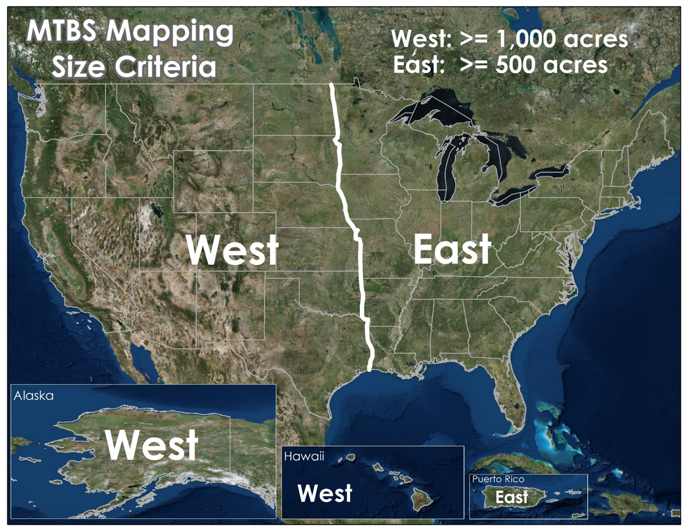
MTBS inventories and maps all known large fires within the United States, regardless of fire origin or type. Fires within the continental United States as well as Alaska, Hawaii and Puerto Rico are included. Large fires include those in the western United States that are at least 1,000 acres in size and those within the eastern United States that are at least 500 acres in size. Alaska and Hawaii are in the western zone, Puerto Rico is in the eastern zone (see the map below). Known fires are those that are documented in fire occurrence databases ingested by the program (see the following FAQ below for more information). Additionally, undocumented fires that are identified by mapping analysts during the analysis process are also inventoried and mapped if they meet the MTBS program's size and location requirement.
How does MTBS know where the fires are located for mapping?
MTBS primarily utilizes IRWIN and NFPORS to identify the occurrence of wildland and prescribed fire activity for the current year and recent past years. These fire reporting applications include fire occurrence data harvested from source systems of record provided by state and federal agencies/organizations. Fire occurrence data with reasonably precise geospatial descriptions (latitude/longitude) are compiled and standardized to generate a point location dataset. Core database elements are compiled as a part of this dataset and include, but are not limited to, the fire incident ID and name, fire type, reported fire size, date of fire ignition, date of fire containment, date of fire declared out. The MTBS program uses this dataset to support all phases of the fire mapping process (i.e., to determine the appropriate assessment strategy, selection of appropriate satellite image data, association of the fire information with the appropriate burn area identified using remote sensing data, etc.). In seeking additional information about an incident(s) that is not reported by MTBS, please use fire reporting data from the IRWIN and NFPORS websites.
Why are some fires missing from the MTBS database?
A fire may be missing from the MTBS database for the following reasons:
- The size of the fire was misreported. A 5,000 acre fire may be missed if it is reported as 50 acres.
- Inaccurate reporting of date of ignition, containment, or location may lead to a fire not being assessed at the proper time and location, thus making it unlocatable.
- Poor image quality. Near cloud-free observations of both pre-fire and post-fire imagery are required in order to produce an accurate mapping.
- Fires of very low severity may not be visible in the imagery and thus not possible to delineate or characterize.
- The fire was not present in the wildfire and prescribed fire occurrence data collected from state and federal agencies/organizations
How were the particular MTBS fire size thresholds determined?
The focus of MTBS is to assess the environmental impacts of large wildland fires and identify the trends of burn severity on all lands across the United States. This does not require a census of all wildland fires that have occurred, nor is that feasible due to the resource constraints and technical limitations. During the planning stages of the MTBS program, an analysis of historical wildland fire occurrence data determined that targeting fires >= 500 acres in the eastern United States and >= 1000 acres in the western United States captures approximately 95% of the annual area burned. These size specifications provide MTBS the ability to meet the monitoring requirements specified in the original scope of the program within a reasonable cost and timeframe
What is a revised fire?
A "revised" fire is a modified version of the originally released geospatial data and mapping products for a mapped MTBS fire. Typical reasons for updating a fire may include the availability of higher quality imagery, edits to the burned area boundary or updates to the severity thresholds. When a revision of a fire is conducted, the geospatial data and mapping products are recompiled and republished. The originally published MTBS dataset is removed from the data distribution archive.
What do Initial Assessment and Extended Assessment mean?
Each fire that is mapped by MTBS has either an "Initial" or "Extended" assessment strategy. An Initial Assessment relies on post-fire satellite data typically acquired at the first opportunity after the fire in order to capitalize on the maximum post-fire data signal and is used primarily in ecosystems that exhibit rapid post-fire vegetation response (i.e. grass, herbaceous and particular shrubland systems). An Extended Assessment relies on post-fire satellite data typically acquired at the peak of the growing season following a fire in order to include any delayed first order fire effects (e.g. initial site response and early secondary effects).
What are the definitions of the fire types in MTBS data?
- Wildfire - An unplanned, unwanted wildland fire including unauthorized human-caused fires, escaped wildland fire use events, escaped prescribed fire projects, and all other wildland fires where the objective is to put the fire out (definition currently under NWCG review).
- Prescribed Fire - Any fire intentionally ignited by management actions in accordance with applicable laws, policies, and regulations to meet specific objectives.
- Wildland Fire Use - An event dealing with the management of a naturally ignited wildland fire to accomplish specific prestated resource management objectives in predefined geographic areas outlined in the Fire Management Plans. The 2009 Guidance for Implementation of Federal Wildland Fire Management Policy recognized only two types of wildland fires: Wildfires (unplanned ignitions) and Prescribed Fires (planned ignitions). Following this guidance, the term Wildland Fire Use is no longer used to categorize fires after 2009.
- Unknown - A fire event whose incident type was not reported from the original reporting agency.
- Complex - Two or more individual incidents located in the same general area which are assigned to a single incident commander or unified command.
- Out of Area Response - Multiple resource response to a wildfire incident. This term applies exclusively to wildfire incidents.
Are MTBS mappings revised?
Yes. If a need to revise a previously released MTBS dataset is necessary, the geospatial data and mapping products are recompiled accordingly and then republished. The original MTBS dataset is removed from data distribution and replaced with the updated dataset. For this reason, we suggest that each time a user begins a project using MTBS data, they download and use the latest datasets available from the MTBS website. See also, "I have found an MTBS dataset that has a problem. What do I do?" under the Geospatial Data tab of FAQs.